

Sensor Integration Experience.
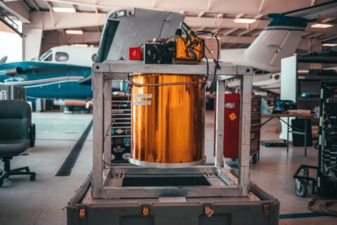
Dynamic Aviation specializes in aircraft platform modification and sensor integration, supporting a wide range of advanced mission systems provided by our customers. We work closely with clients and sensor manufacturers to integrate hyperspectral, electro-optical/infrared (EO/IR), LiDAR, and other specialized payloads into our aircraft platforms.
Our team provides the aircraft, structural modifications, power distribution, mounting solutions, data architecture, and operational integration required to successfully deploy customer-supplied sensor systems. With extensive experience integrating complex technologies across diverse mission sets, Dynamic Aviation delivers reliable, mission-ready airborne platforms tailored to each customer’s requirements.
Sensor Types Integrated (a partial, publicly listable portfolio)
- Optech | Aquarius
- Optech | Shoals 1000
- Optech | Shoals 3000
- Optech | CZMIL
- Optech | CZMIL Nova
- Optech | Galaxy
- Optech | Titan
- Optech Pegasus HA500
- Riegl | VQ-820G
- Riegl | VQ-480i
- Riegl | LMS-Q680i
- Riegl | LMS-Q1560
- Sonoma | 474HR3
- Sigma Space | HRQLS
- Sigma Space | HRQLS2
- Sigma Space | HAL
- Urban Robotics | PeARL V5
- Urban Robotics | Black PeARL
- Vision Map | A3
- Vision Map | MIST DMC
- Wescam | MX-14
- Wescam | MX-15
- Wescam | MX-20
- Wescam | MX-25
- LD3 | FLS-AM
- LD3 | FLS-AI
- Lecia | AHAB Chiropetra II
- Lecia | ADS50-II
- Lecia | ALS70SU
- Lecia | ALS70CU
- Lecia | CU80
- LOGOS | Leaps OCO
- Optech | Orion C300-1
- Optech | Orion M300
- Optech | Orion H300
- Optech | Gemini ALTM
- Optech | Gemini ALTM 3100
- Optech | ALTM 3070
- Optech | Pegasus HA500
- Optech | Pegasus HD500
- ARGON ST | Daedalus
- Azimuth | 36010
- BAE | BTS
- DRS | Sensor Series 3.1
- FLD | xxxxx
- FLIR | STAR SAFIRE
- HyVista | HyMap
- Harris | GmAPD
- HIFSA | DMC
- Itres | CASI-1500
- ITT | MFLL Telescope
- Lecia | ADS40
- Lecia | ADS80
- Lecia | AHAB Hawkeye III
Hyperspectral Sensors
Hyperspectral sensors are remote sensing instruments that capture data across a wide range of the electromagnetic spectrum, typically spanning hundreds of narrow spectral bands. Unlike traditional sensors that record only a few broad wavelength bands, hyperspectral sensors provide detailed spectral information for each pixel in an image. This enables precise characterization of materials and identification of subtle spectral signatures. Hyperspectral imaging finds applications in fields such as agriculture, environmental monitoring, mineral exploration, and defense.
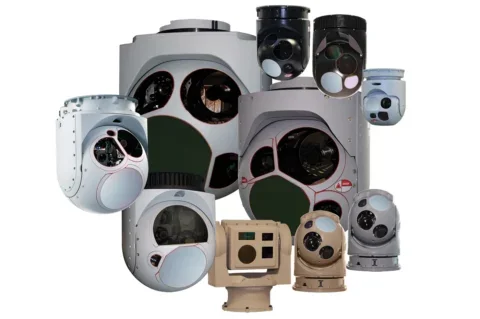
Turret Cameras
Turret cameras are specialized imaging systems designed for various applications, including intelligence, surveillance, and reconnaissance (ISR). These cameras are typically installed on aircraft, unmanned aerial systems (UAS), or other platforms to provide enhanced situational awareness and data collection capabilities. They often incorporate a combination of electro-optical (EO) and infrared (IR) sensors, along with advanced features such as image stabilization, long-range capabilities, and target tracking.
EO/IR Imaging Sensors
EO/IR (Electro-Optical/Infrared) sensors are imaging systems that combine optical and infrared technologies to capture visual and thermal information from the environment. These sensors are utilized in surveillance, target identification, navigation, and reconnaissance across military, defense, law enforcement, aviation, and maritime applications, allowing operators to detect, track, and monitor day or night, regardless of lighting conditions.

LiDAR Sensors
LiDAR (Light Detection and Ranging) sensors are remote sensing devices that use laser light to measure distances and capture detailed 3D information about the environment. By emitting laser pulses and measuring their return time, LiDAR sensors can calculate precise distances to objects and create highly accurate 3D maps or point clouds of the surroundings. LiDAR sensors are utilized in mapping and surveying, autonomous vehicles, environmental monitoring, infrastructure and construction, and archaeology.
COMINT
COMINT (Communications Intelligence) systems are essential for intercepting, monitoring, and analyzing communication signals. These systems capture various forms of communication, including voice, data, and digital transmissions, to extract valuable intelligence, and are vital in military, defense, intelligence, law enforcement, and cybersecurity operations.
ELINT
ELINT (Electronic Intelligence) systems are essential for intercepting, analyzing, and exploiting electronic emissions from radar systems, electronic warfare platforms, and other electronic devices, providing insights into radar capabilities, electronic signatures, and potential threats.
SIGINT
SIGINT (Signals Intelligence) systems are instrumental in collecting, intercepting, and analyzing various types of signals to gather intelligence. These systems encompass both COMINT and ELINT capabilities, targeting communication signals and electronic emissions to provide actionable intelligence for strategic planning, threat assessment, and operational decision-making.
Gravity Gradiometers and Magnetometers
Gravity gradiometers and magnetometer sensor systems are specialized tools used for geophysical surveys and exploration. Gravity gradiometers measure variations in gravitational forces, providing valuable information about subsurface density variations, used to map underground structures, identify geological features, and locate mineral deposits. Magnetometer sensor systems measure variations in the Earth’s magnetic field and are employed in mineral exploration, archaeological surveys, and detecting buried objects.